
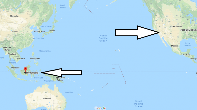
Where is Indonesia? Located in The World? Indonesia Map
Where is Indonesia? / Where is Indonesia Located in The World? / Indonesia Map – Its official name is the Republic of Indonesia. Indonesia is a country of team islands located in Southeast Asia. Indonesia lies between the Indian Ocean and the Pacific Ocean. Indonesia, consisting of 7.508 Islands, is located on the equatorial line. Indonesia is known as the world’s largest archipelago state.
Where is Indonesia?
The country is located in East Timor and Papua New Guinea, south of Australia, north of Malaysia. Indonesia ranks fourth in the world after China, India and the United States. These regions formed by Indonesia are composed of eight main regions. It is grouped into a main island and small islands around it. The capital of the country is Jakarta city located on the island of Cava. In Indonesia, the world’s most populous Muslim country, there are people who have faiths such as Christianity, Hinduism, Buddhism and communism.
Indonesia, which consists of many islands, has many ethnic groups with different languages, religions and cultures. The official language of the country is bahasia or Indonesia. Other than Indonesian, English is also widely used in the country. Indonesia, dominated by tropical climate, is one of the hottest and humid countries in the world. There are direct flights from many capitals of the world to Indonesia. There are many places to visit and see in the country. When it comes to Indonesia, the cities of Bali, Lombok and Jakarta usually come to mind. However, the country is rich in tourist structures and many tourist islands are located. If you get in the way, don’t go back without visiting these places. If you have any questions, we’il be happy to answer them.
Quick facts
| Population | 248,216,193 |
| Density | 137.0 / km2 ( 354.9 / mi2 ) |
| Language | Indonesian |
| Independence Year | 1949 |
| Capital | Jakarta (Jakarta Raya) |
| Currency | Rupiah |
| GDP | 889,000,000,000 (2014 data) |
| GDP per Capita | 3,582 (2014 data) |
| Land Area | 1,811,569 km2 (699,450 mi2) |
| Water Area | 93,000 km2 (35,907 mi2) |
| Neighbouring Countries | Malaysia, Papua New Guinea |
| Minimum Longitude | 95.010 |
| Maximum Longitude | 141.030 |
| Mininum Latitude | -10.990 |
| Maximum Latitude | 5.910 |
Also, You can read this articles:
Raja Ampat Islands : The Raja Amat Islands are located in Indonesia. It is an archipelago of 1,500 islands and islets. According to research, underwater life is the richest place in the world. There may be many reasons for this. But according to some researchers, there are reasons such as the absence of a settlement and the absence of virgin nature.
Tanjung Puting National Park : This Park is located on Borneo Island, the Kalimantan region of Indonesia. Opened in 1982, the Park is very popular in terms of ecotourism. Lots of wild animals are found here. Guided tours are arranged here.
Toraja Land : Toraja is a living area of a tribe with the same name. in other words, it is a mountainous area of South Sulawesi. Be sure to do a good job before you get here. Because the people living in this region have so many different traditions that they will surprise you.
Map of Indonesia
Picture of Indonesia
Is Indonesia a country or a continent?
Which countries are in Indonesia?
What part of the world is Indonesia?
Is Indonesia is in India?